6 Days
Specific Tour
30 people
___
The Kuari Pass Trek, situated in the Garhwal region of the Indian Himalayas, is a remarkable high-altitude journey known for its stunning vistas and unique experiences. It provides a grand spectacle of some of the Himalayas’ most iconic peaks, including Nanda Devi, Kamet, Dronagiri, and Trishul.
This trek, with a moderate difficulty level, spans approximately 28 kilometers, making it suitable for a diverse range of trekkers, from novices to seasoned adventurers. It is a year-round trek, but it transforms into a winter wonderland from December to March, offering a completely different experience with snowy landscapes.
The trail takes you through dense oak and rhododendron forests, vibrant alpine meadows like Gurson and Khullara, and pristine alpine lakes such as Tali and Khullara Lake. These natural wonders create a picturesque backdrop for the trek and offer plenty of opportunities for photography.
Cultural encounters with the local villagers in the Joshimath region provide a deeper understanding of the indigenous culture and way of life. The trek is named after Lord Curzon, the former Viceroy of India, who explored this route in the early 1900s.
Quick Information about Kuari Pass Trek
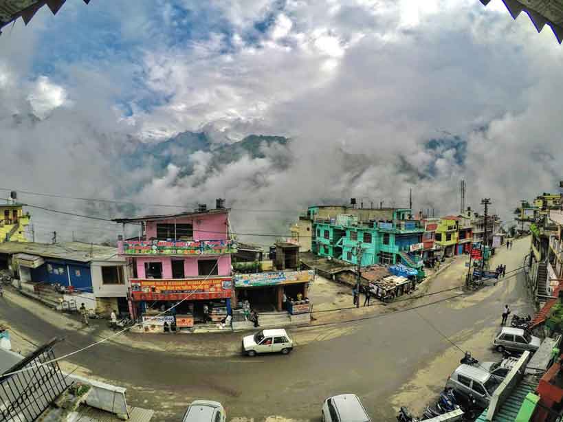
Day 1: Rishikesh to Joshimath
Day 2: Joshimath to Dhak to Gulling
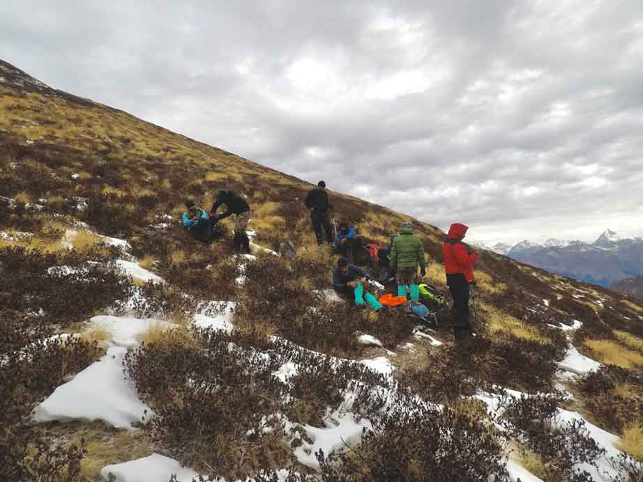
Day 3: Gulling to Khullara
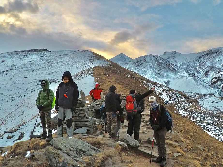
Day 4: Khullara to Kuari Pass and back
Day 5: Khullara to Joshimath via Gorson Bugyal and Auli
Day 6: Joshimath to Rishikesh
The Kuari Pass trek offers a moderate level of difficulty, suitable for both novice and experienced trekkers. The trail consists of varied terrains, including well-defined paths, rocky sections, and occasional steep ascents and descents. Trekkers should be prepared for uneven surfaces and changing trail conditions.
Reaching a maximum elevation of 12,760 ft (3,890 m) at Kuari Pass, proper acclimatization is important to handle the effects of higher altitudes. Trekkers may experience symptoms of altitude sickness, and it is essential to acclimatize, stay hydrated, and maintain a steady pace.
Physical fitness and prior experience with hiking or trekking are beneficial in tackling the challenges of the Kuari Pass trek. Regular exercise, including cardiovascular activities and strength training, can help build endurance and stamina.
The best time to visit Kuari Pass Trek varies depending on the season and the experience you’re seeking. Here’s a breakdown of the best times season-wise:
If you’re an adventure seeker and love snow, winter is the best time to visit Kuari Pass. The region transforms into a winter wonderland, with heavy snowfall and temperatures dropping to as low as -6°C at night. Trekking during this season offers a unique and challenging experience, with the landscape covered in pristine snow. However, winter treks require specialized gear and experience, so they are suitable for seasoned trekkers.
Spring is a fantastic time to visit Kuari Pass. During this period, the snow begins to melt, and the rhododendron and other alpine flowers start to bloom. The weather is generally pleasant, with daytime temperatures ranging from 7°C to 15°C. It’s an ideal season for trekkers who want to witness the vibrant flora and the snow-capped peaks.
Early summer is another great time to trek to Kuari Pass. The snow has mostly melted, offering clearer trails and warmer temperatures. Daytime temperatures range from 15°C to 20°C, making it comfortable for trekking. The lush green meadows are in full bloom, and you can enjoy the breathtaking views of the Himalayan peaks.
Kuari Pass is not recommended during the monsoon season. The region experiences heavy rainfall, which can lead to slippery and muddy trails, making it unsafe for trekking. Landslides and leeches are common in the monsoon, so it’s best to avoid this season.
Autumn is a popular season for Kuari Pass trekking. The post-monsoon period offers clear skies, pleasant daytime temperatures (15°C to 20°C), and fewer chances of rain. It’s an excellent time for trekkers who want to experience the trek without the heavy monsoon crowd.
Ultimately, the best time to visit Kuari Pass Trek depends on your preferences, whether you prefer a vibrant spring, a lush summer, a serene autumn, or a snowy winter adventure. Be sure to plan accordingly and consider your trekking skills and equipment for the chosen season.
It is recommended to arrive in Rishikesh a day prior to the trek’s commencement. Our trek starts from Rishikesh, and our pickup time is set for around 6 am in the morning.
Travel from Haridwar to Rishikesh:
Direct Travel to Joshimath:
Transportation to Joshimath:
Trekkers joining Nomad Adventures will be transported from Rishikesh to Joshimath in rugged and dependable vehicles, such as Bolero, Tata Sumo, Traveller, and other similar vehicles.
To ensure a smooth and enjoyable Kuari Pass Trek experience with Nomad Adventures, we recommend planning your travel and arriving in Rishikesh a day before the trek’s commencement. Safe travels, and get ready for an amazing adventure! 🏔️✨
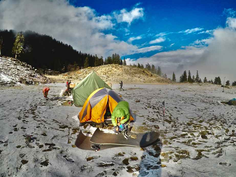
If you’re gearing up for the Kuari Pass adventure, you’ll want to know about the accommodations and culinary treats along the way. The journey commences from the charming town of Joshimath, located in Uttarakhand. This will serve as your base camp, and while the accommodation options here are cozy, they may require sharing rooms on a triple or quad basis, with dormitories as an option.
As you venture further into the trek, you’ll find yourself nestled in spacious and comfortable tents. These tents, on twin, triple, and quad sharing bases, are the perfect retreat after a day of exhilarating hiking. For our female trekkers, we’ve arranged separate tents and rooms, ensuring privacy and safety throughout the expedition.
When it comes to meals, your culinary journey begins with dinner on day 1 and continues until morning tea on day 6. You’ll be treated to scrumptious and wholesome hot meals, including breakfast, lunch, evening tea with delectable snacks, steaming hot soup, and dinner, each accompanied by different desserts daily. These thoughtfully crafted meals provide the essential nutrition you need to conquer the trek.
To keep you hydrated and energized, we supply hot drinking water daily at the campsite, ensuring you remain in peak form throughout the journey, free from the impacts of altitude sickness.
When preparing for an active adventure like the Kuari Pass Trek, it’s vital to think about how to remain comfortable in varying weather conditions. The key to achieving maximum comfort with minimal weight lies in appropriate layering. Versatile layers that can be mixed and matched provide the right balance of insulation, ventilation, and weather protection.
To help you select the right gear, we’ve compiled a comprehensive gear list. It’s essential to pack only what is necessary, not only for your comfort but also to make the trek more manageable for the field staff.
What to Bring on the Trek:
Remember to pack wisely and leave unnecessary items behind to keep your backpack light. A well-planned packing list ensures a safe and comfortable trek, allowing you to fully savor the beauty of nature.
Mule/Porter Bag Offloading:
If you prefer not to carry your backpack, you have the option to entrust it to a porter or mules. Please inform us in advance.
Clock/Baggage Room for Extra Luggage:
Trekkers can utilize the luggage storage facility at the Joshimath base camp to store any extra belongings before commencing the Kuari Pass trek. However, it’s advisable not to store valuable items in the facility to ensure the safety of your possessions.
Our campsites are pitched near water sources. For your day’s trek, two liters of water should be enough. You will find water sources on the trek to refill your water bottles. Your trek leader will brief you about these before starting the day’s trek.
During the trek, toilet tents will be set up along each campsite. A toilet tent will have a deep pit, where one can answer nature’s call. There will be a mound of soil and a shovel to cover it up. These are dry toilets, where you’ll have to use toilet paper. This is the most hygienic and convenient way to answer nature’s call in the wild. Please use plain toilet paper and refrain from using wet wipes since these are not biodegradable.
If it starts raining while you’re trekking, we will continue on the trail as planned. Your poncho should protect you from the rain. Carry a backpack cover for extra protection from rain for your belongings.
Alcohol is dangerous in extreme cold, especially at high altitudes. Contrary to what people believe, alcohol does not make you warmer. Instead, it opens your pores, making your body colder. Moreover, it dehydrates you very quickly. Hence consumption of alcohol is absolutely prohibited on all Nomad Adventures treks. Anyone found with alcohol is quickly removed from the trek. Smoking, similarly, is not allowed on Nomad Adventures treks.
No, but there are shops on the base camp from where you can rent shoes, jackets and trek poles, headlights etc.
You don’t need special snowshoes. A good waterproof trekking shoe is sufficient for the trek. When there is snow, we provide micro spikes and gaiters.
A trekking pole gives you stability and balance and helps reduce fatigue.
The minimum age limit is 8 years. However, minors aged between 8 to 17 should be accompanied by their parents or guardians. The maximum age is 60 but please follow the fitness regime before coming on the trek.
Kuari Pss is an easy trek but requires trekkers to be physically fit. The minimum age eligibility is 8 years. As a parent or guardian, if you feel that your child can adapt to the conditions of the mountains and would be able to walk every day as required, then certainly, yes!. It is recommended to maintain good physical stamina before coming on the trek.
The last electricity charging point would be in Joshimath. You’ll get only the Bsnl/Airtel network over there. However, come prepared for the possibility of power cuts at Sankri. It is good to carry your power banks and extra batteries for your camera.
All high-altitude treks come with their share of risks. We pay utmost importance to the safety of trekkers. While we do our bit to ensure a trekker is safe, we also expect any trekker who is enrolling with us to know what could go wrong, and if it does, how to tackle it.
Since you will be starting and returning to the guest house in Joshimath, it is possible for you to leave some luggage behind, if required. However, make sure you do not leave any valuables. Nomad Adventures is not responsible for loss or damage to any belongings.
No, but in case you are having so please consult your doctor because there are lots of myths about Diamox.
If you want to offload your rucksack, you will have to inform us in advance so that the necessary arrangements are made. You will be charged per day for offloading your rucksack. If you decide on the spot then the charges are higher than usual.
Member Since 2022